


Industrial risk is moving faster than periodic monitoring can handle. Science-grade Earth observation offers a more consistent way to track change across assets, sites, and portfolios.
By Chris Johnson
In heavy industry, problems usually have a long tail before they become visible. Vegetation gets a little closer to a transmission line. Moisture patterns change around a mine site. Ground movement looks minor until it starts affecting an asset, a claim, or a maintenance decision.
The financial reality of this shift is undeniable. Swiss Re estimated global insured natural catastrophe losses at US$107 billion in 2025, the sixth consecutive year above US$100 billion. That number hides a harder truth. Catastrophe risk doesn’t arrive as a single event — it compounds across sites, corridors, regions, and portfolios.
For operators, insurers, and risk teams, waiting for visible damage is becoming harder to defend. The real challenge is knowing when conditions are changing before those changes turn into disruption, loss, or claims.
Periodic “check-ins” are giving way to continuous monitoring. Today, high-stakes decisions are tied to automated models and strict thresholds. Whether managing a utility corridor, a mine site, or a global insurance-linked portfolio, the priority is a reliable, defensible record of how those assets are evolving over time.
The End of the ‘Snapshot’ Era
Satellite observation has already solved one problem for large asset networks: access. Pipelines, powerlines, mines, industrial sites, and regional infrastructure often stretch across broad, difficult, and remote areas. Earth observation gives operators a way to monitor those assets as connected systems.
But coverage is only the first step. In operational settings, the harder question is whether the data can support a decision.
A detected change is not automatically a usable signal. It may reflect vegetation encroaching on a transmission corridor, moisture shifting around a mine site, or heat stress building around infrastructure. Or it may simply be noise — a different viewing angle, acquisition time, sensor response, atmosphere, or processing pipeline.
That uncertainty is the hidden cost of inconsistent data. When teams cannot compare each observation against a reliable baseline, they are forced to interpret the data before they can interpret the risk.
From ‘Pretty Pictures’ to Hard Evidence
Data that is only good for “interpretation” is no longer enough. It has to support decisions.
The insurance industry is already confronting this problem. The International Association of Insurance Supervisors warned in its 2025 Global Insurance Market Report year that a lack of reliable data or models can drive up the cost of insurance and limit affordability.
For insurers and risk teams, data shapes how exposure is understood, priced, and managed. That makes trust and continuity in the data essential. Risk teams need more than isolated observations. The question is whether today’s signal can be compared with last month’s across different sites and hazards, without rebuilding the context from scratch.
Measurement-grade Earth observation gives risk teams a repeatable record, supporting exposure analysis, claims context, model updates, and operational decisions.
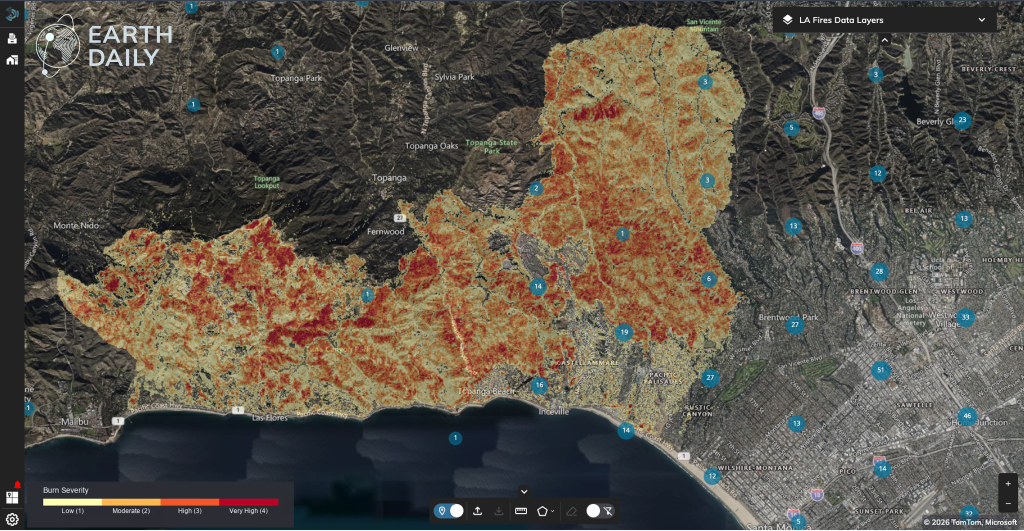
Burn severity data displayed in EarthDaily’s Ascend platform helps users assess wildfire impacts across affected landscapes, turning post-event imagery into actionable layers for response, recovery, and risk analysis.
AI-ready data earns its name when it becomes a record that models and risk systems can actually use. Consistency is what unlocks it. When the same location is observed repeatedly under comparable conditions, the data can trigger an alert, refine an exposure view, recalibrate a risk model, or flag change across a portfolio.
Measurement as the New Operational Baseline
This is the “science-grade” shift currently happening in Earth observation. We are moving from mere image collection to precise measurement. Practically, this means controlling the variables that matter – coordinated imaging, stable viewing geometry, and calibrated multispectral data. It turns independent “snapshots” into a continuous, usable record.
Spectral depth is one of the most powerful tools here. By capturing signals across visible, infrared, and thermal ranges, we can track moisture, heat stress, and material degradation. When these layers are captured consistently, they stop being pixels and start being a diagnostic tool for asset health.
The satellite industry is finally catching up to this demand. The latest expansion of the EarthDaily Constellation is designed around this requirement. The objective is not merely to increase the number of images, but to ensure consistent, accurate measurement at a global scale. For the industrial user, this makes change easier to track and risk easier to quantify.
For any organization managing infrastructure at scale, the bar has been raised. Visibility is no longer enough. The new baseline for industrial risk is evidence you can quantify, compare, and defend.
AUTHOR BIO
Chris Johnson, Vice President of Insurance at EarthDaily, where he leads strategy and growth for geospatial risk solutions supporting insurance, government, and enterprise markets. He brings extensive experience building and scaling SaaS businesses, developing high-performing teams, and driving operational performance across product, sales, and customer delivery.
Manufacturing & Engineering Magazine | The Home of Manufacturing Industry News